fbpx
Earth Science for society
Earth Observation for rural development
Remote sensing for a sustainable Land Management

Welcome

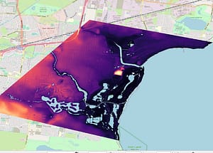
Deep physics space tech venture, for hydrological, soil moisture assessment using airborne and spaceborne data. High resolution hyperspectral and multispectral data  interpretation for rural urban planning, and Earth observation for a more democratic new space Global ecosystem. 

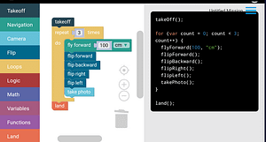
Our vision is to inspire geospatial business leaders and encourage them to get involved in drone technology.

WHAT WE DO

Spatial Science to the Board

  • Aerial Image Classification: 

  • Supervised Classification 

  • Machine Learning Tools 

  • Plant Disease Detection:

  • Multispectral Analysis 

  • Change Detection 

  • Raster Functions: 

  • Raster Functions for Analysis (NDVI) 

  • Geoprocessing Tools 

  • Geoprocessing Tools for Spatial Analysis 

DRONE DESIGN LAB IMG_20240625_185539-1-scaled Home
DRONE DESIGN LAB Villages-scaled Home
DRONE DESIGN LAB Minimal-Tabloid-Landscape-scaled Home
DRONE DESIGN LAB Black-Creative-Professional-Photographer-Online-Portfolio2 Home

Expand your career in the drone industry.

DRONE DESIGN LAB Screenshot-2023-10-22-190827 Home

Work with innovative technologies such as robotics and coding.

DRONE DESIGN LAB 5mDEM_Lidar Home

Data collection and analysis. Hire us for a drone based project.

OUR PARTNERS

DRONE DESIGN LAB partner-1-logo-e1672415234556 Home

SDGs

DRONE DESIGN LAB Copy-of-E_WEB_15 Home
DRONE DESIGN LAB Copy-of-E_SDG_goals_icons-individual-rgb-04 Home
DRONE DESIGN LAB E-WEB-Goal-02 Home
DRONE DESIGN LAB Copy-of-E_WEB_17 Home
DRONE DESIGN LAB Copy-of-E_WEB_13 Home

IF you have any questions?

Scroll to Top
Scroll to Top